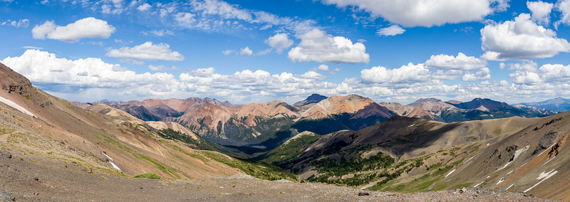
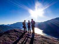
Backpacking the Southern ChilcotinOn July 24 to Aug 1, 2017 Dave and I spend nine days hiking in the spectacular Southern Chilcotin mountains of British Columbia. It's not as remote as other areas we have backpacked - with mountain bikers and horse riders keeping us company - but it's a region as scenic as any we have visited. Day 1: We drive (with some navigation errors) to the Jewel Creek trailhead and then hike Gun Creek trail for 9 hours arriving wearily to a camp at Hummingbird lake. Day 2: We continue along the Gun Creek trail passing Trigger Lake to arrive at a camp at Warner Lake. We spend the remainder of the day exploring the trail to Warner Pass. Day 3: Today we hike through Warner Pass and explore the mountaineering route up Denain Spur. We find the ridge steep with lots of rock fall potential and unsure footing. At the ridge top we admire the view and admonish our foolish spirit to gain this ridge. We also don't see an obvious route beyond the ridge. We carefully descend and return to our camp at Warner Lake. Day 4: We leave camp early and take a bushwacking "shortcut" uphill through forest, crossing meadows, hopping streams, passing tarns and snowfields. We use our rusty compass and map skills to find the Deer Pass Trail that eventually leads us to the main camp at the summit of Sheba Ridge beside a disappointing pond surrounded by dirt and exposed to the cold persistent wind. After lunch and a short snooze we find a better camp in a grassy depression beside a clear stream. A classic high alpine camp! In the afternoon we scramble up Mt Solomon and see the twin peaks of Mt Sheba in the east. Day 5: Today we explore the mountaineering approach route to Mt Sheba in the hope of using it to return back to the car. The route rises steeply and crosses several steep talus sections with considerable exposure. As we approach the flanks of Mt Sheba (with the twin peaks hidden) we stop for lunch at a scenic promontory. Going further would require extensive downhill so we return using an alternative mountaineering route that proves more enjoyable than the trail. High on the ridge we enjoy the 360° views then snooze in the mountain grass away from the wind. Later we slowly descend seeing our yellow tent glowing in the distance below. Day 6: We leave our high camp on Sheba Ridge and descend the Deer Pass trail to camp at Trigger Lake. Day 7: We hike the Gun creek trail to Cowboy Camp and then hike to Spruce Lake. Day 8: Today we explore the approach to Mt Sheba from the east using an old connector trail from Cowboy Camp. We find the main trail that leads to the ridge line connecting Mt Sheba. However, before reaching the ridge we discover the trail washed out by a mudslide requiring a sketchy traverse across a steep gully to bypass the washout. On the ridge plateau forest fire smoke obscures the views toward Mt Sheba. We opt for a lunch and a snooze rather than proceeding further. Day 9: From Cowboy Camp we hike 12.5 km back to our car and end another fantastic backpacking adventure. During our travels we meet several times a horse handler who appears to have been hired directly from cowboy central casting.
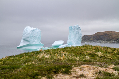
A visit to The RockIn June/July of 2018 we visit Newfoundland (aka The Rock), a destination that is not well known even for Canadians. But if you can brave the wacky weather, enjoy a bracing wind, and love the unpredictability of the outdoors then Newfoundland should be on the top of your must-do list. Our initial motivation to visit Newfoundland was to see massive icebergs as they wander down the coast. However, 2018 was a relatively inactive iceberg season but we did manage to see some impressive bergs in St Anthony. In place of icebergs we found an impressive number birds, especially the iconic Atlantic puffin and the diving northern gannets. The hiking and scenery in Gros Morne Park was everything we had hoped it to be, especially the ascent of Gros Morne Mt in a blustery blowing wind and the boat cruise up Western Brook Pond. And no trip to Newfoundland would be complete without a trip to France! A short ferry ride transports you to the a small (and very) french village of St. Pierre.
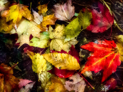
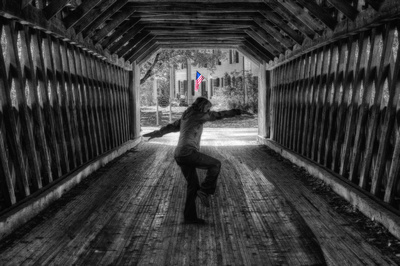
Autumn in New EnglandIn Oct 2016 we travelled through Massachusetts, Vermont, New Hampshire, and Maine to experience an east coast autumn. We tried to time our trip to coincide with peak fall colours, adjusting our destinations based on fall foliage predictions. In search of coloured, dying leaves we also discover nine covered bridges: six in Vermont, two in New Hampshire, and one in Maine. We hike several trails surrounded by autumn splendour, visit quaint New England towns, and shiver on Mt Cadillac waiting for the sun to rise. Covered Bridges of New England
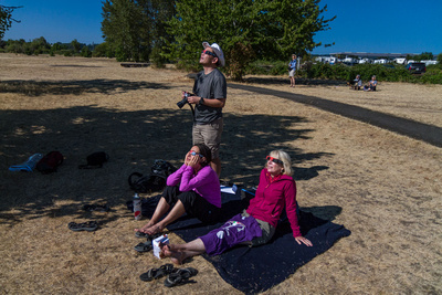
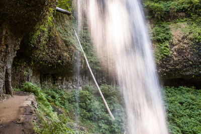
A total solar eclipse and 9 waterfallsIn late August four intrepid travelers brave clogged freeways driving south to Oregon. Why? To experience a total solar eclipse, of course! On Monday August 21, 2017 we arrive early in Salem, find a viewing area, and wait for the show. Is a solar eclipse worth the logistic details: traffic, cost, weather, crowds? Emphatically, yes! Read about the eclipse at my photo blog After the eclipse we head east to Silver Falls State Park for some hiking and to avoid traffic heading north. Oh, this park has several waterfalls. Some very unique waterfalls. Ten waterfalls, in fact; we visit nine.
Cape Scott, Haida Gwaii, and Angel's CrestOn Aug 12 I load the car and begin a series of adventures travelling 4700 km – a distance from Vancouver to Québec City – that end a month later. But my journeys were confined only to British Columbia beginning with a backpacking trip on the North Coast Trail in Cape Scott Provincial Park in northern Vancouver Island. Then, after a shower and shave and one home sleep, the car is equipped for a trip to the fabled islands of Haida Gwaii (via Prince Rupert) for hiking and exploration. Finally, I throw different gear into the car and head to Squamish to climb the Stawamus Chief from bottom to top. Photo stories for each trip can be found at the links below (especially convenient for mobile or touch devices): Click on the thumbnail links below to visit the photo gallery for each trip.
© Wolfgang Eilers
|